Cartosat DEM Download and Mosaicing Process using QGIS
This article is prepared to discuss steps to download Cartosat DEM through bhuvan portal. As this DEM downloaded in tiles so one may need more than one DEM tile for study area.
Therefore it is necessary to mosaic these tiles to make a single tile of DEM. In this steps of both processes- download and mosaic are shared to create DEM, which can be further used further for different remote sensing and GIS based applications. Such as
- Agricultural Studies
- Wetland studies
- Watershed Studies
- Runoff and Sediment Discharge Studies
- Urban Sprawl Mapping
- Transport Studies etc.
Step 1 –
Download freely available DEM data using NRSC-Bhuvan website
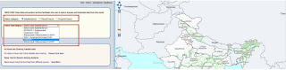
Open weblink: http://bhuvan.nrsc.gov.in/bhuvan_links.php
From this page go to top menu option – Open Data Archive
- A new window will open after clicking on Open data Archive.
- You need to make user id on this page, so click to Login (on the extreme top right corner)
After login
- Select the area of which you need to download Cartosat data by providing Place name, Lat/long.
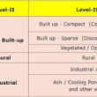
- Select category – Satellite/Sensor to download Cartosat DEM data
- Select Sub Category– Cartosat-1 as shown in below figure

Now
- Select Product – CartoDEM All versions or here you can select the version as per your requirement

After providing above mentioned details scroll down and go to Select Area– In that different options are provided to select area such as bounding box, mapsheet, tiles and interactive drawing.
- Bounding box- in this you can provide extent of your study area.
- Mapsheet- 50K toposheets no. of your study area.
- Tiles- select by clicking on tiles in the right screen.
- Interactive drawing- one can draw random polygon based on study area in the right screen to select tiles.
Here in this explanation tiles option is used and tiles are selected in right screen by clicking on the tile. For multiple selections of tiles use shift button.
- Click on Start Button for tiles selection

Now selected tiles are visible in red color as shown below. Click on Next Button

- Downloadable Images are displayed in left part of screen, so now you can download DEM data based on year/date of pass by clicking on download option.
*You can view the DEM data, before download by clicking on View in Add to Map column

After download of all DEM tiles of your study area, you can view these DEM datasets into QGIS. Click on Layer then Add Layer followed by Add Raster Layer.

The Data Source Manager-Vector window will pop up.

Here you have to Browse (for the DEM data) and select the GeoTIFF image. Then click on Add button and close the window. Like this you can open all the DEM images as shown below.

Now these data sets need to be mosaiced
Step 2 –
Mosaic DEM data using QGIS
If you study area covers more than one DEM tile then Mosaic process is required. The mosacing of the Cartosat DEM is used to merge the multiple DEM tiles into single DEM layer.
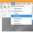
Click on Raster then go to miscellaneousfollowed by Merge.

A new popup window will open (Merge)


*Don’t forget to check the check box ‘open output file after running algorithm’ and Click ‘Run’. When process if finished close the window. Mosaiced DEM is ready for further processing.
Use extent on Canvas

But DEM data might have different co-ordinate system so before further process of DEM, one need to re-project the DEM.
It is really a great work and the way in which you are sharing the knowledge is excellent.Thanks for your informative article
Help Desk app
It is good that Bhuvan has come out with open data archive system. Countless users are benefitted with it.
Please check the 'values'. Today, i have noticed that along the shore line, the elevation value is -240. The negative values surprised me. inlnad values are also negative values. I have checked this northern outskirts of Mumbai.
Gets the best Rockfon education standard ceiling tiles
Many thanks for sharing such incredible knowledge. It's really good for your Website.
The info on your website inspires me greatly. This website I'm bookmarked. Maintain it and thanks again.
I'm really impressed with your writing skills, as smart as the structure of your weblog.
Output Portal Crack