Spatial Data Creation
Spatial data can be created using any GIS software, these spatial data can be created as line, point and polygon through which any feature of earth surface can be represented.
All the linear features of can be represented by line entity, where as enclosed or area can be represented by polygon, these spatial data also called as vector data.
GIS has many function and tools which can apply to create spatial data. These spatial data can be apply to many field for further studies.
In this article, spatial data creation through QGIS software is discussed.
Line Feature creation in QGIS
Open QGIS by clicking on Start then go to All Programs and then click QGIS Desktop 3.8.3
Following window will open

Open the georeferenced toposheet via Layer then click Add Layer followed by Add Raster Layer

Following pop up window (Data source manager raster) will open. Browse and select the georeferenced toposheet for line features (line is used to create linear features like road, railway, drainage etc) creation via Raster data set and Add button.
Georeferenced toposheet will open.

Now for Line layer creation, click on Layer then click Create layer followed by New Shape file Layer

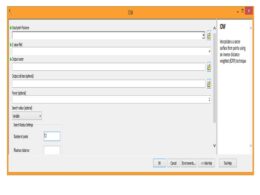
New Shapefile layer window will popup

Now In the above popup window define the File name.

Select Geometry type – ‘Line’ as here we want to create line layer.

Now specify Coordinate reference system (CRS) same as toposheet. For this click on Select CRS. A CRS selector popup will open, here define the co-ordinate system and Click on ‘OK’

Specify the attribute fields to the layer that we have created. If we want to create layer of roads then we will add ‘Name’of the road as new field and Road type as other fields.
For New field to be added, an appropriate Name, Type(like text, whole number, decimal number and date) and Length must be selected.


Click on ‘Add to Field List’ and the attribute will be added to the field list as shown below

In the same way, you can add other fields like Road type etc. and once all the fields added, click on OK.
Note: If you want to remove the added field from the list, select the field you want to remove and click on ‘Remove Field’ button.

The line layer created by you will be visible in Layer as shown below

Now you can start digitization, but before starting digitization you have to enable the editing mode of the corresponding layer. Right click on ‘JP_roads.shp’ line layer and click on ‘Toggle Editing’ as shown below

Zoom into the toposheet where roads are seen, Place the cursor at feature of interest and click. But before that select the symbol of road and this could be selected from Style manager. For this click on Settings and then go to Style manager as shown below

Following window will popup. Here select the symbol of your choice and close this Style manager window.

Now click on Add Line feature icon from digitizing toolbar.

Note: If Digitizing tool bar is not present in your QGIS window, then right click on main menu bar area and check the Digitizing toolbar as shown below

Now place the cursor on the road and start road digitization by using left mouse button to insert vertices. When road bends or changes its profile, then insert more vertices to get smooth curve.
At the end of the road click on the right mouse button to stop. ‘Attributes’ window will open, fill in the required attributes for example Name is ‘kuchaman road’ and Type is ‘metallic’, then click OK.

In the same way you can digitize other roads and define their attributes. Click on Save Layer Edits icon in Digitizing tool bar, to save the line layer along with its attributes.

Note: We will suggest that after digitization of one road, you should use snapping tool to digitize the remaining roads. Snapping tool is very effective to reduce the digitization errors like overshoot and undershoot. For this
Click on Settings then go to Options as shown below

A popup window will open, here select Digitizing and then in Snappingoption check the box indicating Enable snapping by default. Snapping tolerance can be set manually. After specifying the snapping tolerance, click OK

If you want to edit any attribute information, then open the attribute table of ‘JP_roads.shp’ by right clicking on this layer and select Open Attribute Table as shown below.

Select the attribute by double click and edit it. Now save the edits and after saving click once again on the toggle button to stop editing. Line layer creation and editing is over now.