What is Hydrology
Hydrology encompasses the study of water on and beneath the surface of the earth, occurrence of water, movement of water, physical and chemical properties of water and its relation with the surrounding environment.
‘Hydro’ word comes from the Greek word, which means water and logy means study. So study of water can be defined as ‘hydrology’.
Hydrology studies indirectly also related to many other studies such as land use/land cover studies, forestry, agriculture, since existence of water in these studies play significant role.
Changes in hydrology are dynamic, it changes with years as well as with change in season and bring huge impact on surrounding environment.
Therefore require regular and sometimes frequent observations to assess and control the negative impact on hydrology of any given area.
Remote Sensing and GIS in Hydrology
Satellite remotely sensed observations enhance understanding of hydrological studies and impact of surrounding environment on hydrological processes by having global spatial and time series satellite data of near real time.
The remote sensing and GIS is a best tool to assess and analyze water qualityconsistently and understanding the natural environment on a local and regional scale.
There are many surrounding factor which affect the surface as well as ground water quality. Such as
- Water drains from different type of land use/land cover, it may enrich with different kinds of contaminants as runoff from agricultural lands may be enriched with nutrients and sediments.
- Likewise, runoff from highly developed urban areas may be enriched with rubber fragments, heavy metals, as well as sodium and sulfate from road deicers.
- Increase in population, urbanization, industrialization over exploiting water resources and environmental pollution has been deteriorating the quality and quantity of local water resources.
Remote sensing data and processes are very useful in below hydrological applications-
- Wetlands mapping and monitoring
- Water quality monitoring
- River and lake mapping and monitoring
- Flood mapping and monitoring
- Drainage mapping and watershed studies
- Irrigation studies
- Ground water studies
- Soil moisture estimation
- Determination of snow cover
- Sea water studies
Image processing and interpretation are used for qualitative characterization of hydrological mapping. Recent developments in remote sensing have also used thermal, multi-spectral data, high resolution satellite images and radar images for hydrological studies.
The application of multi spectral and high spatial resolution remotely sensed images is increasing in mapping and estimating, which have been notices in many studies.
GISplays a significant role in the application of spatially distributed data in hydrological studies. GIS is integrated with database and different hydrological models such as SWAT, may enhance the use of remotely sensed data in hydrological applications.
GIS have many mathematical modelswhich can be employ to create spatially data, which can be represented in the form of quality maps of turbidity, pH, Fluoride etc.
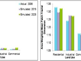
There are some below examples of water quality spatial data created using GIS tool-

Water Quality Spatial Data

Water Quality Spatial Data
nice
A web application is a computer program that allows you to log-in to a web address to collect and retrieve data from/from databases on the Internet, these programs include web technologies such as HTML, CSS, JS, etc. Is developed using. And can be accessed using your favorite web browser. Web applications help you streamline your business processes so that you can get more done in less time and with greater accuracy. IT Consulting Brisbane provides Professional email, online storage, shared calendars, video meetings, and more. Built for business, designed for teams. Thanks for this beneficial article.
Great post. Measuring soil moisture is important in agriculture to help farmers manage their irrigation system more efficiently. Know more information about Soil temperature and humidity sensor and probe,Visit at UbiBot Online Store!
Wonderful article, Which you have shared about the Moisture Absorber. Your article is very important and I really enjoyed reading it. If anyone looking to buy Moisture Absorber at online, then visit at Moisture Absorber for Cabinets
Sequential and Exception test Very efficiently written information. It will be beneficial to anybody who utilizes it, including me. Keep up the good work. For sure i will check out more posts. This site seems to get a good amount of visitors.