What is GPS and How does GPS work? GPS (Global Positioning System) GPS is a satellite-based navigation system used byadminMarch 22, 2025
How to subset a satellite image in ArcGIS? The ability to subset a satellite image to concentrate on a particular area of byadminMarch 4, 2025
How to Change Band combination of satellite image in ArcGIS Use of Band Combination in Satellite Image Processing In satellite image byadminFebruary 24, 2025
Layer Stacking or Band composite of Landsat Satellite data using ArcGIS Integration of numerous spectral bands of Landsat byadminFebruary 17, 2025
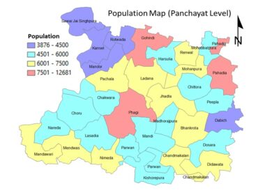
GIS Analysis GIS DataApril 21, 2022 Population Map Using GIS- Population Map of Phagi @ Panchayat Level Case Study GIS for Generation of Population map GIS is a versatile tool, which can be used byadmin
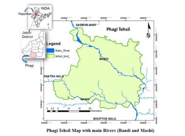
GIS DataApril 8, 2022 Generation/Creation of Layers/Maps using GIS Database creation using GIS of Phagi Block, Jaipur GIS is a versatile tool byadmin
GIS DataApril 12, 2020 What is Vector Data Model of GIS Vector Data Model As discussed in raster data article that earth surface byadmin
GIS DataApril 11, 2020 What are the Raster Data Formats in GIS and Remote Sensing???? Raster Data Formats used in GIS and Remote Sensing Earth surface features byadmin
GIS DataMay 28, 2019 What is Geo-Spatial Data Geo-Spatial Data – Spatial and Non-Spatial Data Data is raw form of byadmin