GIS is a very important tool that can be used in application and analysis of data. GIS provide spatial perspective platform to analyze data. GIS allow to integrate both spatial and non-spatial (attribute) data to understand the real time scenario of earth surface.
GIS is advantageous for many applications and fields to monitor and manage the real world issues. GIS functions and tools are useful to analyze spatial data and impact of surrounding environment by incorporation location based factors.
In this article application of GIS for delineation of watershed is discussed. GIS can integrate both vector data and raster data for analysis, therefore watershed based studies become very useful.
Watershed
A watershed is an area of land that drains all the streams and rainfall to a common outlet such as reservoirs, bays, and the ocean. It combines with other watersheds to form a network of rivers and streams that progressively drain into larger water areas. Topography determines where and how water flows.
Some watersheds are small in area however; others encompass thousands of square miles.
Importance of Watershed Delineation
There are many environmental stresses, which is affecting land and surrounding areas. For example, the main stressors affecting the coastal ecosystem are sediments and nutrients from the terrestrial ecosystem, which occurs through river transport and via drainage basin network.
In the Coral Coast of Viti Levu Island, Fiji, coral reefs have been rapidly deteriorating because of population growth, coastal development, tourism, coral and live rock harvesting, agriculture, deforestation and other factors.

Therefore, watersheds are important because the surface water and storm water runoff within a watershed ultimately drain to other bodies of water. Hence, suitable land use practices and water management practices are necessary for implementing water quality protection and restoration actions within a watershed.
A healthy watershed conserves water, supports sustainable streams, rivers, lakes, and groundwater sources, and enables healthy soil for crops and livestock, also support habitat for animals and plants.
Watershed Delineation
The process include five major steps:
- Digital Elevation Model (DEM) Set-Up,
- Stream Definition,
- Outlet and Inlet Definition,
- Watershed Outlets Selection
- Definition and Calculation of Sub-basin Parameters
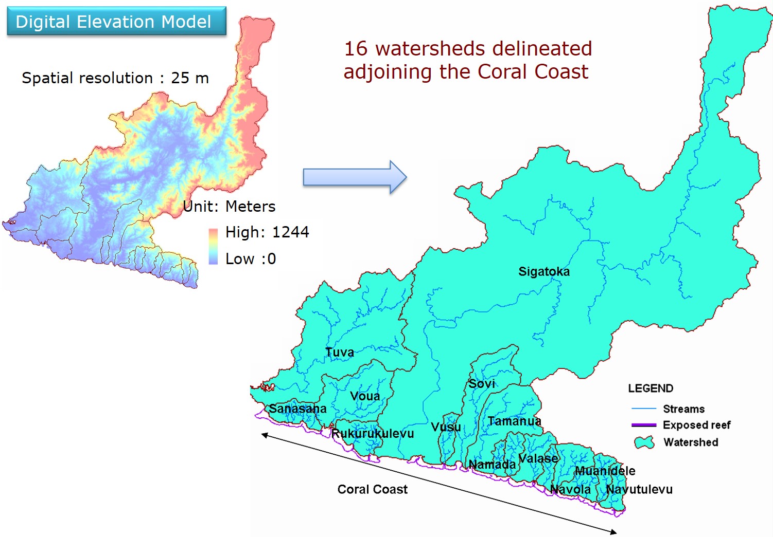
The contours were digitized from the topographical map of 1:50,000 scale using GIS software. The digital elevation model (cell size 25x25m) of Viti levu island, Fiji was developed using digitized contours.
The DEM was used to delineate the watershed and to analyze the drainage patterns of the land surface terrain. A predefined digital stream network layer was imported and superimposed onto the DEM to accurately delineate the location of the streams.
It is a proficient article that you have shared here about Geo-Spatial Technology used for Watershed Delineation. I got some unique and valuable information from your article. Thankful to you for sharing this article here. Irrigation system installation Waterville