Geo-Spatial Technology for Wetland Mapping
Wetlands refer to lowlands covered with shallow and sometimes temporary or intermittent waters. Wetlands include marshes, swamps, bogs, wet meadows, potholes, shallow lakes and ponds.
However deep lakes, reservoir and permanent waters of streams are not considered as Wetlands. Hence we can say wetlands are transitional lands between terrestrial and aquatic systems where the water table is usually at or near the surface.
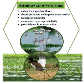
Wetlands posses a great ecological significance in terms of, net primary production, micro-climatic control, ground water recharge and habitat to large number of flora and fauna.
It also plays a vital role in nutrient recycling and storage as well as biodiversity conservation. Wetlands help to retain water during dry periods, thus keeping the water table high and relatively stable.
Rapidly expanding human population, large scale changes in land use, different development projects and improper use of watersheds have caused the decline in wetland resources of the country.
The encroachment of wetlands leading to the extinction of rare aquatic species. The negative impacts on wetlands are mainly caused due to sediment load, pollution, aquaculture development and weed infestation.
The suspended micro particles along with toxic substances are transported from agricultural lands and effectively interface with the incoming solar radiation. This result in reduced photosynthetic activity and lowering of redox potential, causing impeded respiration to heterotrophs as well as degraded spawning habitat.
Finally it promotes over growth of algae and aquatic plants (eutrophication), which depletes oxygen, creates turbid condition, reduce species diversity (as sensitive species are replaced by lower number of less desirable species).
In addition decrease in primary production is associated with increase in sedimentation and turbidity and produce negative cascading effects through depleted food availability to zooplanktons, insects, fresh water mollusks, and fishes.
Hence there is a need to create inventory of various wetlands and their periodic assessment in terms of aquatic conditions.
For wetland management, the first and foremost task is to make its inventory and distribution. Remote Sensing data by virtue of its synoptic, multi-spectral and repetitive capability can be used suitably to demarcate the wetlands, changes in wetlands spread and time varying wetland profile.
High resolution satellite data with multi-spectral capability helps to accurately identify even the smallest wetlands, their turbidity level and the aquatic vegetation.
Turbidity level can be examined by selective use of satellite bands as turbidity is directly related to optical density of the medium, however aquatic vegetation could be identified through band combination because red band absorbed by the vegetation and infrared is reflected depending upon the vigor and pigment concentration.
Subscribe to Our Newsletter
Get notified of the best deals on our WordPress themes.


You have a genuine capacity to compose a substance that is useful for us. You have shared an amazing post about weed infestation. Much obliged to you for your endeavors in sharing such information with us. ak47 auto seeds
These thoughts make individuals curious. Your work enhances the information you provide. Asian Seeds Online Australia
I liked your work and the way in which you have shared this article here about black indica. It is a beneficial and helpful article for us. Thanks for sharing an article like this.
Excellent information, This information will always help to everyone for gaining knowledge. So please always share your valuable information. I am very thankful to you for providing good information. Weed Seeds
I am very thankful to you that you have shared this information with us. I got some different kind of knowledge from your web page, and it is really helpful for everyone. Thanks for share it. Read more info about bc bud delivery
You have given great content here about how Downtime Tracking is helpful to increase the Business Research . I am glad to discover this post as I found lots of valuable data in your article. Thanks for sharing an article like this.
Supreme Court cleared finest way|the method in which} to authorized sports betting in 2018, states have raced to open the taps of tax income from the apply. Thirty states and the District of Columbia have reside, authorized sports betting, and five more states have reside sports betting on finest way|the method in which}. Anyone who provides gambling providers has a responsibility to develop policies and 카지노사이트 packages to handle underage and gambling addictions.