Spatial data can be manages and analyzed using GIS. In current, GIS application is increased in transportation studies especially in planning and management. Public transport system is an important part to manage and plan for urban development.
Public transport symbolizes as an efficient mode to travel by the people for different purposes in the specific region with the less impact on the environment.
Therefore urban planners and decision makers need to identify useful approach to deal with resistance of people to travel by public transport. It is become important to evaluate and identify the areas which are poorly connected with public transport system but at the same time those areas need to provide public transportation due to availability of high rate of potential users.
Public transport system is accessed through its stop/station, so it is important to know and estimate coverage area of stop/station. The coverage area is significant for public transport that the increase in the working people and residence in the proximity of transport system, this increase the probability that the transport system will be used.
In other case if the distance to access stop/stations are too great, then it is less preferred to be utilized as a mode of travel.
GIS can be used to evaluate efficiency of public transport system and can be used to estimate the coverage area of public transport system based on population in coverage area.
GIS spatial analysis tool can be used demarcate geographical area of public transport system and further compute the population in that coverage area. This coverage area can be identifying for each stop of public transport and use to estimate the demand of public transport at their stops.
It is known that the proximity to stops or stations of the transport system will affect to a great extent the demand of potential users. Therefore it is significant to estimate the potential users in the coverage area of public transport stops.
There are different methods, which can be used to estimate of coverage area such as straight line and road network method using GIS tool.
GIS is a vital tool for formation of What IF scenarios and it is can be implemented using GIS for evaluation of plan and policies took on for development of transport system.
Therefore in this article, GISis used to create coverage area for stops of public transport using road network method.
Delineation of Coverage Area of Bus Stops using GIS
The straight line distance method around stops or stations is very easy to use and do not consider road network which is main key as people will access transport system by these road network.
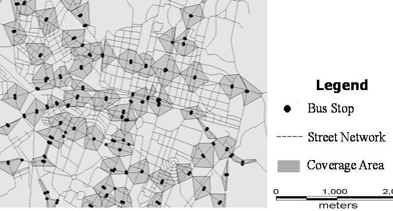
So, road network based distance concept is used to create coverage area. Coverage area is created by taking 400m distance from the stop and this 400m distance can be defined as a comfortable walk under standard circumstances for all people.
Therefore, bus stop coverage area is delineated by estimation of the 400m walk able on a street network from every stop public transport network and then demarcates the coverage area.
These coverage areas in the form of polygons can be created for all route stops (Figure A).

The steps followed for delineation of coverage area using GIS are following:
- 400m distance is used for coverage area delineation as it represents the maximum distance that most people are willing to walk to use bus services.
- Calculation of distance over the street network, in accordance with 400m distances specified from each stop.
- Obtainment of polygons using this distance over the road network to calculate the coverage area of each PT stop.
- Overlapping of layer of polygon with the built area layer in order to calculate the built area within each polygon.
- Obtained built area in each polygon used as coverage area for further analysis.
- Overlapping coverage area of bus stops are separated using GIS tools.

Last Sunday, I needed to travel somewhere on an emergency basis. That's why I hired a taxi and the driver of the taxi was so friendly and helped me to reach my destination in time. I hired the taxi from Taxibel Centrale which is the best taxi provider in Zwolle. Taxi rservation
In an accident, a taxi is my first resort. Since the taxi still gets me to my destination on time when I have to go to their emergency room. About the fact that I live in Zwolle, I still use Taxibel Centrale to get around. taxi Zwolle app.
Thanks you for sharing this unique useful information content with us. Really awesome work. keep on blogging
Hire .Net Developers