Download free satellite images of Indian Satellite using NRSC-Bhuvan website
Bhuvan portal is a platform created by National Remote Sensing Center of Govt of India to provide free satellite images of different satellite such as LISS-III, LISS-IV, Cartosat DEM etc. This portal also provide free classified and thematic maps.
These satellite image can easily download by select and preview process.
Open weblink: http://bhuvan.nrsc.gov.in/bhuvan_links.php
From this page go to top menu option – Open Data Archive

- A new window will open after clicking on Open data Archive.
- You need to make user id on this page so click to Login (on the extreme top right corner)
- A new small window will open for login credentials, scroll down it and click on New User

- Create login id by providing details such as user name, email id, first name, last name etc.

- Go to click here to login and also an email sent to your email id, activate that email id and login in bhuvan portal through your login credentials.
- After Login start searching satellite data of your study area by using below steps
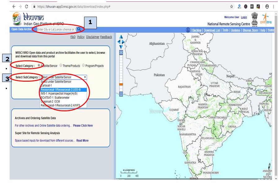
- Select the area of which you need to download satellite images by providing Place name, Lat/long.
- Select category – Satellite/Sensor to download satellite images
- Select Sub Category– Name of satellite/Sensor is provided, so select as per need, as in this Resourcesat/LISS-III selected
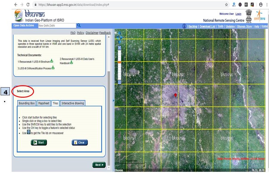
4. After providing satellite/sensor details scroll down and go to Select Area– In that different options are provided to select area such as bounding box, mapsheet, tiles and interactive drawing.
- Bounding box- in this you can provide extent of your study area.
- Mapsheet- 50K toposheets no. of your study area.
- Tiles- select by clicking on tiles in the right screen.
- Interactive drawing- one can draw random polygon based on study area in the right screen to select tiles.
- In this explanation tiles option is used and tiles are selected in right screen by clicking on the tile. For multiple selection of tiles use shift button.
Now scroll down and
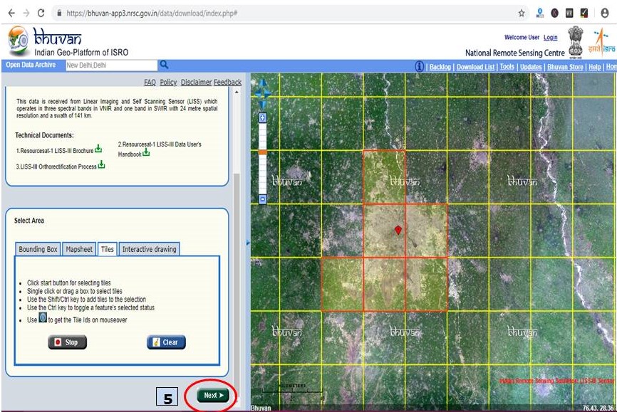
Selected tiles are visible in red color
5. Click on Next Button (In above Image)
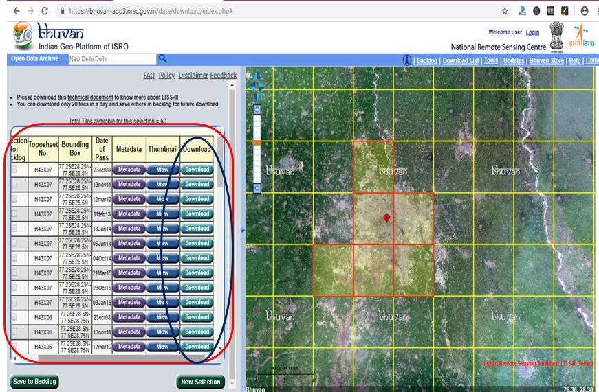
Downloadable Images will display in left part of screen, one can download image based on year/date of pass by clicking on download option.
Watch Video of this article by clicking on below link—
**all the images source is from BHUVAN website of National Remote Sensing Center.
Information is awesome…..
This article seems to be very useful for the people who are new to the area and have to start their learning from scratch
Great… A little more explaination of category choices and sub category may help the novice users….
I guys there is a new website here I have checked it out you guys can also check this Govt Jobs btj6h
It’s really amazing to get this blog and information in this blog may give the right information…!!
Tally Classes in Chennai
CCNA Training in Chennai
SEO Course in Chennai
Big Data Training in Chennai
Cloud Computing Courses in Chennai
Blue Prism Training Chennai
Hey what a brilliant post I have come across and believe me I have been searching out for this similar kind of post for past a week and hardly came across this. Thank you very much and will look for more postings from you best free ad posting sites in India service provider.
it's very cool Movie Free Guy Full Movie Free Download Watch Online 123movies
it's very cool Movie Free Guy Full Movie Free Download Watch Online 123movies
Free guy Full Movie Free Download Watch Online Coolmoviez
Modern Supplies is the Acoustic Ceiling Tiles Australia.
maestro Full Movie Free Download Watch Online Moviesda
Best quality Rockfon Sonar Tiles
Speacial Ops 1.5: The Himmat Full Movie Free Download Watch Online Pagalworld
Good for teaching
I think this is one of the most significant pieces of information for us about Apple Watch Straps Australia . And I'm glad to read your article. Thank you for sharing!
Useful tutorial
Get 10% OFF using with ninja discount code & promo codes Save on new kitchen appliances with Ninja Kitchen promo codes. Buy blenders, coffee machines & more for less !!
Nice