What is GPS and How does GPS work? GPS (Global Positioning System) GPS is a satellite-based navigation system used byadminMarch 22, 2025
How to subset a satellite image in ArcGIS? The ability to subset a satellite image to concentrate on a particular area of byadminMarch 4, 2025
How to Change Band combination of satellite image in ArcGIS Use of Band Combination in Satellite Image Processing In satellite image byadminFebruary 24, 2025
Layer Stacking or Band composite of Landsat Satellite data using ArcGIS Integration of numerous spectral bands of Landsat byadminFebruary 17, 2025
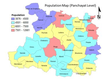
GIS Analysis GIS Data Population Map Using GIS- Population Map of Phagi @ Panchayat Level Case Study GIS for Generation of Population map GIS is a versatile tool, which can be used byadmin
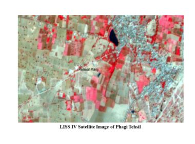
RS Analysis Satellite Data of Phagi Tehsil for Land use Mapping LISS IV Satellite Data of Phagi Tehsil for Mapping Satellite data/images byadmin
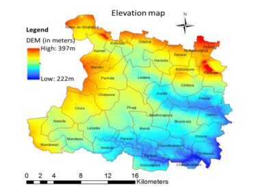
GIS Analysis Digital Elevation Map Generation Using GIS Elevation and Slope map using GIS Topographical information/data are very byadmin
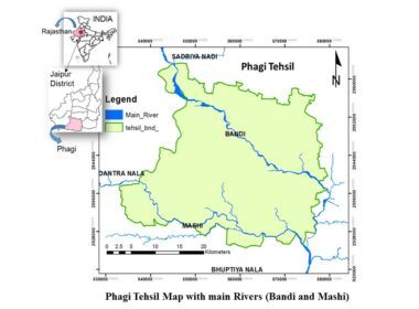
GIS Data Generation/Creation of Layers/Maps using GIS Database creation using GIS of Phagi Block, Jaipur GIS is a versatile tool byadmin
Question Bank GEOMATICS QUIZ-I Introduction to GIS GEOMATICS Question Bank Series Main Topic: GIS Sub Topic: GIS Introduction byadmin
Remote Sensing Data What are Satellite/Sensor Characteristics Satellite/Sensor Properties for Image Processing This article will bring byadmin
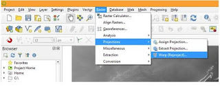
GIS Analysis GIS Tutorials How to Process Cartosat DEM using QGIS- Reproject, Clip and Stream Generation This article is the continuation of an earlier article on downloading and byadmin
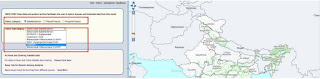
GIS Analysis How to Download Cartosat DEM Through BHUVAN Portal Cartosat DEM Download and Mosaicing Process using QGIS This article is prepared byadmin
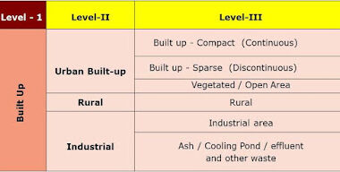
RS Analysis HOW TO DETECT CHANGES IN LAND USE LAND COVER CHANGE USING GEO-SPATIAL TECHNOLOGY Remote sensingis used for change detection and analysis of different earth byadmin
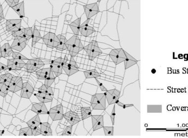
GIS Analysis Geo-Spatial Technology for Public Transport Access Analysis Spatial data can be manages and analyzed using GIS byadmin