Application of Remote Sensing in Land Cover and Land use Mapping

Introduction

Land cover and land use mapping is one the most imperative and typical application of remote sensing. Land cover represents the physical condition of the earth surface features such as forest; grassland etc. 

Whereas land use reflects man-made activities includes use of land such as residential area, industrial zone, agriculture field etc. Land cover include land surface feature, those can be natural, semi-natural and man-made and these features can be observed directly on satellite images

On the other hand, Land use is classified based on utilization of land. 

It can be categorized into residential, commercial, urban, rural and agriculture etc. Land use indicates the employment of the land by human, so if any change or shift in use of land such change from agriculture to residential/commercial for any given location brings the change in land use.

Remote Sensing techniques are the most practical, cost efficient and provide satellite data beyond human vision. Remote sensing provides multi-spectral, and multi temporal satellite images for accurate mapping. 

Land cover/Land use mapping provide basic inventory of land resources. This mapping can be local or regional in scope; it depends on user’s objective and requirement. 

Remote sensing platforms provide variety of satellite images with variation in spatial resolution (pixel size) from centimeter to kilometer as well as in timely manner (repetitive data) from days to weeks.

Process


Land use and Land cover mapping starts with acquiring satellite images. Selection of satellite image for mapping completely depends upon user’s requirement. 

In case of regional mapping, then need to select low resolution satellite images. But for detailed mapping at higher scale then one need to select high resolution satellite images. 

After acquiring satellite image, it should be corrected both radiometrically and geometrically (if require). Image enhancement can be performed to improve the quality of satellite image. 

Image classification can be performed using any image processing software to map the study area. By this process satellite image used for mapping of land use and land cover of any given area.

Application of Land use and Land cover Mapping


Mapping of land cover and land use is important for monitoring studies, resource management and planning. Land cover and land use mapping provide base line data, which can be further used in monitoring and planning activities.

Change Detection is main concern for creating land use map data. As the population is continuously increasing and affecting natural resources, therefore monitoring of natural resources and proper management need high priority for government of any state.

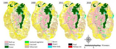
 Figure- Land cover and Land use Map of Four Different Periods (Jaipur)

The change in land use and land cover from rural to urban area can be used to monitoring as well as for predicting/forecasting the future needs for better planning and management.

Figure- Land cover and Land use Map of Four Different Periods (Kota)

Multi temporal analysis using remote sensing data provides a unique approach to detect the change in land use and land cover. The change is usually detected by comparing land use/land cover map prepared independently using at least two multi date images.

The land use and land cover change can be divided in to two broad categories-
  • Seasonal changes- for agriculture change analysis and forest change analysis
  • Annual changes- land use changes in built up areas, urban sprawl studies etc.
To accurate change detection analysis, require multi spectral and multi temporal satellite images as well as high resolution satellite image as per the requirements of the project.

As well as for some other areas to apply land use and land cover mapped data are following-
  • Natural Resource Monitoring and Management
  • Wildlife habitat protection
  • Urban(Built up) Sprawl studies
  • Transportation Planning– logistics management, accident and traffic studies etc.
  • Disaster Studies- Earthquake, Tsunami, land sliding, flooding (including both man-made and natural) etc.
  • Tax and property evaluation
Land use and land cover mapping is significant process using satellite image, which can be used to many monitoring, planning and management process related to earth surface natural and man-made features.
Comments 3
  1. By using the Services, you acknowledge you have got} read, and you conform to be certain by, the phrases of our Privacy Policy. Please check your e mail and click on} on the verification 슬롯게임 link that was sent if you registered your account. Call GAMBLER. Must be physically positioned within the Commonwealth of Pennsylvania to play. Estimating the short-term impact of free-play offers in a Las Vegas Hotel Casino.

Leave a Reply

Your email address will not be published. Required fields are marked *

Prev
Spatial Data Creation using QGIS Software

Spatial Data Creation using QGIS Software

Spatial Data Creation Spatial data can be created using any GIS software, these

Next
Geo-Spatial Technology for Agriculture Studies

Geo-Spatial Technology for Agriculture Studies

Introduction Agriculture is very important for economy of both developed and

You May Also Like