Introduction to Image Classification
Process of Classification
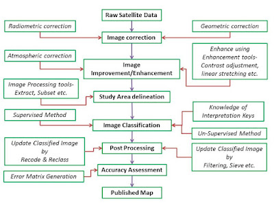
- Classification process starts with the identification of number of classes and classification scheme such as urban, agriculture, forest, river etc. in which all the pixel will be classified.
- In the next stage field conduction/knowledge as well as secondary data need to acquire for classification
- Satellite image pre-processing, it includes geometric correction and radiometric correction as well as atmospheric corrections can be performed as per requirement
- Delineation and extraction of the study area using image processing tool from satellite image for the classification
- Image can be enhanced using various enhancement tools from basic enhancement process such as brightness and contrast adjustment to advance tools for example, linear stretching and gamma stretching etc.
- For image classification in image processing, usually two methods are deployed Supervised and unsupervised
- Supervised method-it is performed using signature collection from satellite image and training sites generation for classification
- Unsupervised Method- Grouping of pixels based on repetitive iterations as well as incorporation of statistical and mathematical approach
- After classification of satellite image post processing performed to improve quality of classification, such as recoding, reclass, sieve and filtering etc.
- In the last accuracy assessed for classified satellite image using accuracy assessment tool, this process performed to assess the quality of satellite image to accept the classified images.


Everyone wants to get unique place in the IT industry’s for that you need to upgrade your skills, your blog helps me improvise my skill set to get good career, keep sharing your thoughts with us.
electronic signature software
Good informative blog
for more information email signature management office 365
anyone can Write Me A Research Paper for my university project in cheap price.
Every website you visit seems to incorporate certain forms of animation. What seems to be trending is considered as liquid-style animation with movement that appears to be a water lifespan. web design trends
This comment has been removed by the author.
SEIM Our IDS/IPS and SIEM system works with the fundamental responsibility of collection, normalization, correlation, and analysis of logs.
shopify developers We have Shopify app Developers who work with a customer focused approach to offer exceptional web application services
time tracking software touches on some of the most important areas of your business. Not only does it help you get paid if you’re charging hourly, but it’s like getting a true image of all the functions and activities happening in an organization
human based company The idea behind it was to make the great teams flourish the performance of the organization just like the teams in the sports. The entire team works hard to win the game. That is the power of synergy
Nice post. I used to be checking constantly this blog and I am impressed! Extremely useful info particularly the ultimate section 🙂 I take care of such information a lot. I was seeking this certain information for a long time. Thank you and best of luck.
disadvantages of internet essay BOOKS PDF DOWNLOAD
Excellent article and this helps to enhance my knowledge regarding new things. Waiting for more updates.
Modern Web Design Trends
Latest Trends in Web Design
In the last exactness evaluated for ordered satellite picture utilizing precision appraisal instrument, this interaction performed to survey the nature of satellite picture to acknowledge the arranged pictures.
The information in the post you posted here is useful because it contains some of the best information available. Best Local Classified Ads Website. Thanks for sharing it. Keep up the good work.
you will need support or suggestions, write me privately.
I interested in your implementation/use case.
the best situs slot terbaik
Togel2win
daftar bo bonanza
Slot gampang menang
I'm extremely inspired along with your writing skills as neatly as with the format in your blog. Is that a paid subject or did you customize it yourself? Anyway stay up the excellent quality writing, it's rare to look at a great blog like this one today.. http://www.remer.com.au
Nice Blog…Waiting for the Next Update…
Digital Marketing Company in Kerala
Digital Marketing Agency in Kerala
You re in purpose of actuality a without flaw website admin. The site stacking speed is astonishing. It sort of feels that you're doing any unmistakable trap. Besides, The substance are perfect work of art. you have completed a fabulous movement regarding this matter! sattamatka
We offer notary services and procedures that are intended to be as quick, easy, and straightforward for our clients as possible.
Are you looking for an eco-friendly way to protect your property from the effects of Mother Nature? Look no further than envirosteam, the leading Cheap Car Wash company in Ottawa. We provide a number of services that not only protect yourCar Wash Prices Ottawa property from the elements, but also improve its appearance. We have a coating for every application, from roofing to window treatments. Get in touch with us today to learn more about our services and to receive a free estimate!
very nice and great article, thanks for sharing with us! mi 10t pro price in pakistan
he entire curriculum is delivered by enthusiastic, knowledgeable instructors in a setting created especiallyAl Areen for martial arts training. To test it out, sign up right away! UAE Alareen Martial Arts is looking forward to meeting you soon!