What is Vector Data Model of GIS

Vector Data Model

As discussed in raster data article that earth surface features can be created in both raster and vector format as per requirement of user. 

For example wetland mapping feature such as pond can be created in both data formats, in vector as polygon and grid/pixels format in raster. 

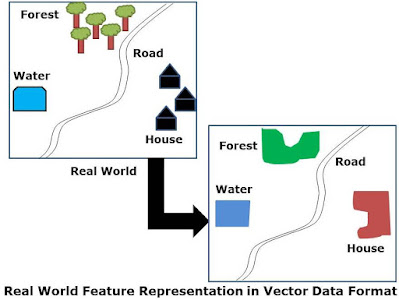
Vector Data Model is an object based approach to the representation of real world features. This data model is best suited to represent discreet objects. 

In this method the entire earth surface feature including man-made and natural can be represented by only three entities in GIS. These entities name-
  • Point
  • Line 
  • Polygon
In this all the features in which only locations is presented than Point entity used for representation in GIS software, However for representation of all linear features, line entity used in GIS tools

To represent any enclosed feature of earth and representation of any feature which has area entity, in that case, polygon entity is used in vector data. This representation also called spatial data in GIS.


Example: Vector GIS Data
  • Point- Hospitals, Wells etc.
  • Line- Highway, River, Canal etc.
  • Polygon- Forest, Agri Land, Urban Area etc.
This spatial data also have information, which need to represent in GIS vector data. Such as in case of point feature Hospital, information such as name, type, capacity and many more information can be provided by that spatial entity/point feature. 

Same method can be used for linear and region features. This representation of information with spatial data is called non-spatial data or attributes.
Example Attributes:
  • City:          Name, Population, State
  • Wells:        Village, Depth
  • Highway:   Type, Number
  • River:        Name, Length
N number of attributes can be attached with spatial data as per the requirement of data and user.

Vector Data Representation

Simple geometric objects of point, line and polygon and their x, y coordinates are used to represent spatial features. 

All the features have different dimensions and property, which can distinguish in the below three types.

Point has 0 dimension and has only the property of location.
Point may also be called
  • Node
  • Vertex
  • 0-Cell
Line is 1 dimensional and also has property of length. Begins and ends with a node.
Line are also known as
  • An edge
  • Link
  • Chain
  • 1-Cell
Polygon is 2 dimensional and has properties of area and perimeter.
Terminologies
Polygons are referred as
  • Area
  • Region
  • Zone
  • 2-Cell

Point& Line Features

Basic unit of the vector data model are points and their coordinates. Line features are made of points. Between two end points a line is a series of points marking the form of the line. 

Different segments may be created to smooth curve or straight lines. Line features may intersect or join with many other lines and together form network.

Polygon Features

Polygons are defined by lines and boundary of an polygon separates the interior area from the exterior area (which may be unbounded). 

All the area features may be isolated or connected with each other. 

It may form holes within other areas. Area features may overlap and create overlapped areas.

Vector Data Advantages

  • It represents more maps like in compare to raster data as it is more accurate and pleasing to eyes.
  • Vector data is very high resolution and magnification does not affect display quality of data.
  • Vector data require less storage space compare to raster data.
  • Vector data are more users friendly and can be understood by public better than raster data.
  • Vector data can also be represented topologically and allows analysis using topological data.

Vector Data Limitations

  • Data formats may be more difficult to manage than raster format.
  • Spatial data stored as long lists of coordinates, which is easier for computer to understand but difficult for users to understand and edit.
  • Vector format creation is more expensive.
  • Vector data processes of GIS are more difficult to learn
  • Topology concept of GIS is difficult to understand.
  • Raster data are easily availability compare to vector data.
Leave a Reply

Your email address will not be published. Required fields are marked *

Prev
What are the Raster Data Formats in GIS and Remote Sensing????

What are the Raster Data Formats in GIS and Remote Sensing????

Raster Data Formats used in GIS and Remote Sensing Earth surface features

Next
Spatial Data Creation using QGIS Software

Spatial Data Creation using QGIS Software

Spatial Data Creation Spatial data can be created using any GIS software, these

You May Also Like