Introduction to Digital Image Processing
Digital Image Processing is the implementation of mathematical methods and algorithm on digital images for correcting, improving, analyzing and creating information.
Nowadays remote sensing data are available digitally therefore process performed on these image also defined as digital image processing.
Image processing is combination of processes in which different techniques deployed for editing, manipulation of digital images using image processing software.
It is important to understand that the main aim of this processing is to extract information from satellite image, which are not readily available in satellite image, such as built up area, water body etc.
To process satellite image digitally, the remote sensing data (i.e. satellite images/aerial photographs) must be recorded and facilitate only in digital form.
Instead of digital satellite images, other requirements of image processing are computer system with appropriate hardware, image processing software and image analyst to process satellite images.
Digital image processing commonly categorize in to five broad categories:
- Pre-Processing
- Image Enhancement
- Image Transformation
- Image Classification
- Post Processing
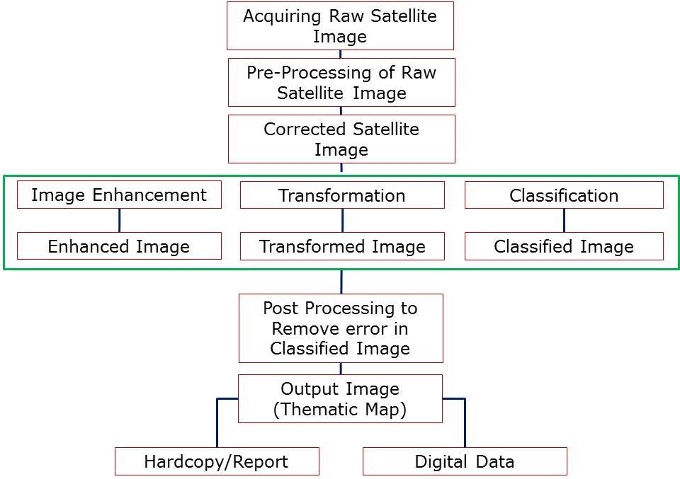
Above image processing steps are implemented to extract information and create user friendly information in the form of thematic map such as land use/land cover maps.
The digital image processing start with acquiring raw satellite images then pre-processing performed on satellite image to remove errors such as radiometric correction and geometric corrections. Some other processes, such as subset, mosaic are also part of pre-processing.
Radiometric corrections include atmospheric corrections, de-stripping etc. Whereas geometric correction, bring the satellite image with reference to earth, which is also called georefrencing.
Next step is to enhance the satellite image quality, it is very important process to reduce, magnify information in satellite images. There are several process for enhance image from basics such as contrast/brightness adjustment to advance methods like linear/non-linear enhancement using statistical and mathematical model. Some more processes such as filtering also used to enhance satellite image.
Image transformation step is used to create, manipulate satellite images for getting more accurate information. In this mostly mathematical operators are used on satellite images to extract significant information.
This process include, use of arithmetic operators such as image addition, image subtraction, whereas Fourier transformation, Tasseled cap transformation, Normalized differential vegetation index and many more used to extract information by transforming images.
In the next, images are classified, which means all the pixels in the satellite image which are representing different type of features/objects assigned to a specific class.
Such as Built up includes all the built area (residential, commercial, Industry etc.) whereas water body covers natural and man-made both type of water body (Lake, River, Pond, Canal, Sea etc.).
So categorization of image pixels in to a class defined as classification. Image classification performed using basically with two approaches, supervised and unsupervised. Both methods are significant and important in the image classification process.
Image post processing is an important part of digital image processing as in this process accuracy and improvisation in classification is implemented. All the wrongly classified pixels are modified using sieve, recode methods.
However accuracy of classified image is assessed to determine the quality of image classification.
After the acceptable accuracy classified image can be defined as final output, which is further used to create report, printout and thematic maps.
I Would like to thank you for this article. From this article I got more and more useful information. This is so helpful to me. Keep updating more articles.
Ubs accounting
Myob Singapore
Best Accounting software Singapore
Good content and thanks for sharing!!
Selenium Training in Ahmedabad
Selenium Training in Delhi
Selenium Training in Gurgaon