Aerial Photographs
These photographs captured through balloon, aircraft and in current drones are used very commonly. These photographs represents aerial view of land use and land cover.
Aerial photographs categorized in vertical, low oblique and high oblique depend upon angle from nadir and area covered in aerial photographs.
These photographs are very useful for mapping and monitoring due its high spatial resolution. Such detail information captured through aerial photographs can be used to create spatial data and further analysis in GIS and Remote Sensing.
Spatial resolution of satellite images can be represented in the form of scale. This scale defined the quality of information, which can be called information in detail. More details information its mean good spatial resolution.
Scale of Aerial Photographs
Scale is the relationship between distance on a map or photo and the actual ground distance. Scale is one of the important parameter for aerial photographs/Satellite Images.
It is calculated before aerial photography, as number of photographs required to map for specific area calculated based on scale defined for the aerial photography.
There are three method defined for scale measurement for aerial photography.
i) By establishing the relation of photo to ground:
If the distance between the same two points on the photo as well as on the ground can be measured, R.F. can be set up:
Scale= photo distance/ground distance
Example-
Q1. Distance between two points AB on ground is 1320 ft, distance on map is 3.77 inch. Find out the scale of photo at average ground elevation of this line.
Ans. For this distance on map and distance on ground given in the question therefore below formula will use to solve this question
Scale= Photo Distance/Ground Distance
First bring both distances (ground and photo) to same unit
So 3.77 inch=0.3141 feet
Scale= 0.3141/1320
Scale will be 1:4202 (As it is representative fraction)
ii) By establishing the relation between focal length of the camera and the flying altitude/height.
In a true vertical aerial photograph when terrain is flat than the scale of photograph is the ratio f/H.
Scale= f/H
where f = focal length and H = flying height
Example
Q2. A vertical aerial photograph is taken over flat terrain with 6 inch focal length of camera; flying height of air plane is 6000 feet above ground. Find the scale of photograph
Ans. As focal length given and terrain is also flat so by considering these two information available in question below formula will be used-
Scale= f/H
First bring both values (focal length and flying height) to same unit
So focal length will be- 6 inch=0.5 feet
Scale= f/H
Scale= 0.5/6000
Scale will be 1:12000 (As it is representative fraction)
(iii) When Terrain is not Flat
As it is known that earth is not flat in that case for scale measurement another method. That is if the terrain is not flat, the scale of the photograph is not uniform.
In below figure, H is the flying height above the average height of the terrain photographed. Then the average scale of the photograph = f/H
The scale of photo for a point A (elevated area), which is at a height of `h’ meters or ft. above the average ground level.
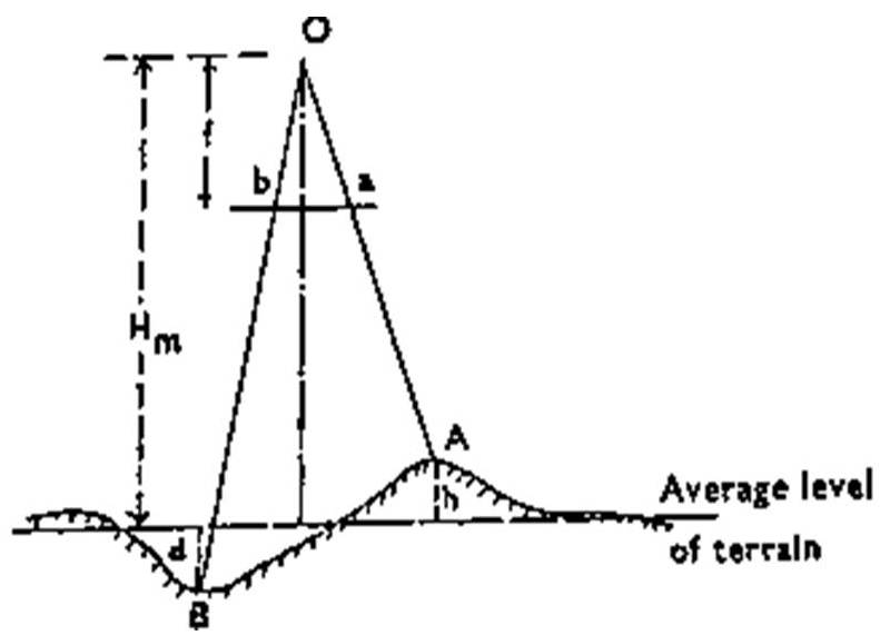
So scale will be
Scale =f/H-h
where f = focal length, h =elevated area above the average ground level and H = flying height
(the units of focal length and the heights being in the same terms).
Similarly the scale for another point B (depressed area), which is at a vertical distance ‘d’ meters or ft below the average terrain level.
Scale = f/H+d
where f = focal length, d =depressed area below the average ground level and H = flying height
(the units of focal length and the heights being in the same terms).
Example-
Q3. At what height above sea level must an aircraft fly in order to produce photo at an average scale of 1:20,000, if average elevation of area 1200m, camera focal length is 210mm.
Ans. In this question flying height need to calculate and scale, average elevation of ground and focal length is provided. So below formula will be used to calculate the flying height.
S=f/H-h
Here S=1/20000; f= 210mm and h=1200m
So if one put these values in the above formula than
1/20000= 210/H-1200
By bringing the right hand side values to common measuring unit than
Focal length of camera is 210mm and if convert it to meter than it will be 0.21m
1/20000=0.21/H-1200
By solving above
4200 = H-1200
H = 4200+1200
So H = 5400 meters
By this way one can calculate the flying height or any other value if any three values are given.
👍👍👍