Land Suitability and Priority Analysis
GIS is a very strong tool which provide platform to integrate mathematical and logical concepts together to create, analyze and interpreted data for planning, monitoring and management of land resources. Below article is one of the example in mathematical and logical concepts combined together to assess suitable or priority land for development purpose.
Land suitability is the assessment of a given type of land for a defined and priority use. The land may be considered in its present condition or after improvements. The process of land suitability classification is the appraisal and grouping of specific areas of land in terms of their suitability for defined uses.
Land suitability analysis aims to identify the most appropriate spatial pattern for future land uses based on specific requirements.
Land suitability analysis involves the application of criteria to the landscape to assess where land is most and least suitable for development of structures and infrastructure. Land suitability can be assessed using in GIS environment by integration of mathematical models.
Multi Criteria Analysis (MCA) using GIS is a technique for standardization of criteria and multiplying each criterion with its weight factor to produce suitability or priority areas.
Land suitability analysis using GIS and the MCA approach has been applied to landscape evaluation, to land use planning and urban development used MCA for delineation of suitable land for crops.
MCA is able to handle the discrete decision situations where the choice-possibilities are measurable and data have a quantitative and/or a qualitative character.
It recommended the integration of GIS and multi-criteria analysis methods to enlighten decision makers in solving problems that contain a spatial dimension. A multi-criteria analysis method can be used for suitability analysis or priority analysis, for example assessment of modeling urban change pattern dynamics and priority areas for forestry inventories.
Urban suitability helps to explain a city’s growth patterns as well as environmental issues. The MCA decision support tool can be implemented for land suitability analysis for urban development. A decision is a choice between alternatives such as actions or land allocations, etc.
In MCA, an attempt is made to combine a set of criteria to achieve a single composite basis for decision making, according to a specific objective. This MCA method is based on a weighted linear combination where criteria may include both weighted factors and constraints.
In weighted linear combinations, factors are combined by applying a weight to each factor and multiplying the suitability calculated from the factors by the product of the constraints.
Land suitability can be assessed by two main attributes, that is, geographical location and physical properties. Geographical location can be defined as distance, such as the relative distance of a piece of land from an urban centre, whereas physical properties include soil properties, water conditions, topography, and size.
Urban suitability or priority areas for forest inventories are more related to location factors, transportation conditions, and topographic features. Factor weights are very important in weighted linear combinations because they determine how individual factors will be traded off relative to each other. Factors established in this phase are not unique, but they are the most relevant.
Suitability levels for each factor were classified and used as a base to construct the criteria maps (one for each factor). The levels are 5 (very high suitability), 4 (high suitability), 3 (medium suitability), 2 (low suitability), and 1 (very low suitability).
Before calculating the weights for factors, it is also important to standardize all factors on a common scale of measurement to facilitate analysis, which is done using a fuzzy set approach. The MCA process defined in simple steps below with figure illustration.
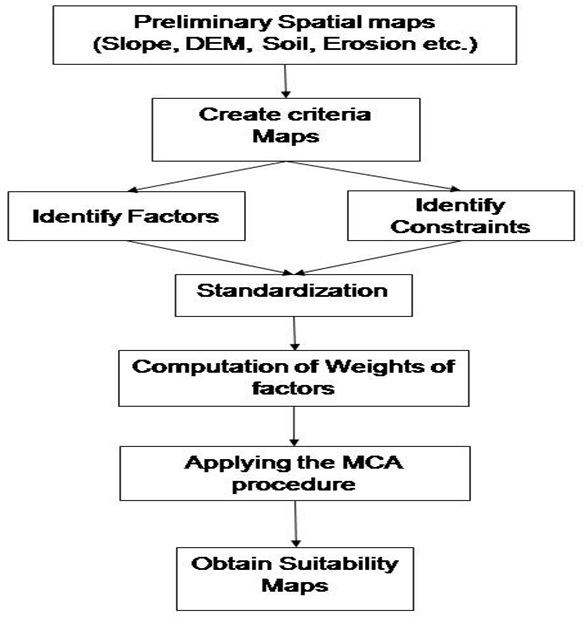
STEPS for Multi Criteria Analysis using GIS and Remote Sensing:
- In MCA, an attempt is made to combine a set of criteria for decision making.
- The MCA method is based on a weighted linear combination it include both weighted factors and constraints.
- In weighted linear combinations, factors are combined by applying a weight and multiplying the suitability calculated from the factors by the product of the constraints.
- Suitability or priority levels for each factor used as a base to construct the criteria maps (one for each factor).
- The levels can be defined as very high suitability (5) to very low suitability (1).
- Before calculating the weights for factors, it is also important to standardize all factors on a common scale of measurement to facilitate analysis, using a fuzzy set theory.
Very nicely written article. In next update you may include case study to demonstrate the methodology.