Remote Sensing
Introduction
The term “remote sensing,” first used in the United States in the 1950s by Ms. Evelyn Pruitt of the U.S. Office of Naval Research. ‘Remote’ means far away and ‘sensing’ means observing or acquiring some information.
Therefore, remote sensing is the acquisition of information about an object or phenomenon without making physical contact with the object.
In our everyday living, one employ remote sensing to view different objects. Our eyes can be considered as sensors that respond to the light reflected from various objects. The data acquired by our eyes are the impulses corresponding to the amount of light reflected from light and dark areas of the object.
This data is analyzed and interpreted by our brain which works like computer, to enable us to recognize the object.
Remote sensing is a tool/technique that use sensors to measure the amount of electromagnetic energy emitting an object or geographic area from a distance and then extracting the information from the data using mathematically and statistically based algorithms. Various sensors are used to collect the data about different objects/areas.
Remote Sensing term generally refers to the use of aerial or satellite sensor technologies to detect and classify objects present on Earth (in the atmosphere, on the surface or in water).
This process involves the detection and measurement of radiation of different wavelengths reflected or emitted fromdistant objects or materials, by which they may be identified and categorized by class/type, substance, and spatial distribution.

Bands-KXCSLP
Source:

Remarks: Brown color indicates absorption areas
Green color indicates reflection areas and useful for Remote Sensing
Paul R. Baumann (2010). http://www.oneonta.edu/faculty/baumanpr/geosat2/RS-Introduction/RS-Introduction.html
Remote Sensing is broadly classified into two categories based on sensors.
1. Passive Remote Sensing:
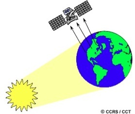
It uses sun as a source of electromagnetic energy. Passive sensors detect energy that is naturally emitted or reflected by the object or surrounding areas.
Examples: Charge-coupled device (CCD) cameras, infrared sensors, imaging spectrometers.
2.Active Remote Sensing:
It uses its own source of electromagnetic energy. The sensor emits radiation which is directed toward the target/object and return energy is measured by the sensor.
Examples: RADAR, LIDAR.
Remote Sensing Data Acquisition Process
It involves seven processes as illustrated in figure shown below
(1) Energy source- First requirement for remote sensing data acquisition is the energy source that illuminates or radiates electromagnetic energy (EM) to the earth’s surface features. Passive RS systems rely on Sun as the source of energy; however active RS systems use its own source of energy.
(2) Energy propagation through earth’s atmosphere – The EM energy travels from its source to the target through the atmosphere. Earth’s atmosphere modifies the strength and spectral distribution of energy and its effect varies with wavelength.
(3) Energy interaction with target – EM energy interaction with earth’s surface features generates reflected/emitted signals (spectral response patterns or signatures). These signatures are helpful in detection, identification and analysis of earth’s surface features.
(4) Energy received by the sensors – The EM energy reflected/emitted from the target is recorded by the sensor. Sensors are electronic instruments which are mounted on board satellites. These sensors are highly sensitive to wavelengths. No single sensor is sensitive to all wavelengths and has fixed limits of spectral and spatial sensitivity.
(5) Data transmission, reception and processing – EM energy recorded by the sensor is transmitted in electronic form to the ground based earth station. After various levels of corrections, these data sets are processed into an image.
(6) Data interpretation and analysis – The processed image is interpreted visually/digitallyby the trained people to extract the information about the earth’s surface features.
(7) Application – The information extracted from imagery can be utilized for several applications and mapping such as natural resource management, wildlife habitat protection, land use/land cover change, crop monitoring and crop damage assessment, urban expansion/encroachment etc.

Fig. Remote Sensing System Process
Great post, Sensors are central to industrial applications being used for process control, monitoring, and safety. For more information Visit @ https://store.ubibot.io/.
virtual cio, We are really grateful for your blog post. You will find a lot of approaches after visiting your post. I was exactly searching for. Thanks for such post and please keep it up. Great work.
Incredibly useful and detailed information. You are growing rapidly and it shows in your blogs.
pii_email Thanks for a very interesting blog. What else may I get that kind of info written in such a perfect approach? I’ve a undertaking that I am simply now operating on, and I have been at the look out for such info.
Nicely done, Thank you for sharing such a useful article. I had a great time. This article was fantastic to read. continue to write about
Data Engineering Solutions